

Hello Friends, in this blog post(How Does GPS Work), we are going to let you know about another amazing and useful technology, “GPS”.
Most of you must already be aware of this GPS technology and would be using it in your daily lives when needed.
Today, it has become very common to quickly open Google Maps and search for a location rather than asking nearby people.
You can easily see your exact location on Google Maps, shown as a blue dot. |How Does GPS Work|
It does not matter whether you are driving through an unknown city, hiking in the mountains,…
… or simply looking for a restaurant; your mobile phone always knows your location.
You could always feel excited and curious about how it happens. |How Does GPS Work|
It is really very amazing to see that there is no wire connection between our phone and satellites.
And these satellites are situated very far, like thousands of kilometres above the Earth.
Still, our phone is able to determine our precise location with remarkable accuracy.
And the technology working behind all this amazing functionality is called GPS, and it is known as the Global Positioning System.
If you really wanted to explore how science, physics, space, mathematics, electronics,…
… and computer technology are working together, then no example could be better than GPS. |How Does GPS Work|
What Is GPS?
GPS stands for Global Positioning System.
It is a satellite-based navigation system that allows a receiver to determine its:
- Location
- Speed
- Direction
- Time
GPS was developed by the United States and is now used around the world for both civilian and specialized applications.
Is GPS the Same as Google Maps?
No.
This is an important distinction.
GPS determines your location.
Google Maps uses your location to provide maps, directions, routes, and places.
For example:
GPS may tell your phone:
“You are approximately here.”
Google Maps then uses that information to show:
“You are on this road, and your destination is 5 km away.”
Navigation apps can also combine GPS with mobile networks, Wi-Fi, maps, and phone sensors to improve positioning.
How Many Satellites Are Used by GPS?
The GPS constellation contains more than 20 operational satellites, arranged so that users around the world can normally see several satellites at any given time.
A GPS receiver generally needs signals from at least four satellites to determine a three-dimensional position and correct its clock.
How Does a GPS Satellite Know Where You Are?
Here’s the amazing part:
The satellite does not need to know where you are.
Instead, your GPS receiver calculates its own position by measuring signals received from several satellites.
Each satellite continuously broadcasts:
- Its position
- Extremely accurate time information
- Other information needed by the receiver
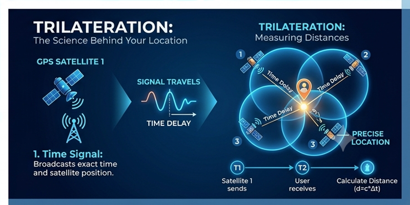
Your phone receives these signals and calculates how far away each satellite is.
How Does GPS Measure Distance?
GPS uses time.
Radio signals travel at approximately the speed of light.
If your phone knows:
- Exactly when a signal was transmitted.
- Exactly when it was received.
It can calculate how long the signal travelled.
Then:
Distance = Speed × Time
Because the signal travels at nearly the speed of light, even a tiny timing error can create a significant distance error.
This is why GPS satellites carry extremely accurate atomic clocks.
Why Are Atomic Clocks Important?
A GPS satellite’s clock must be extraordinarily precise.
Even an error of just a tiny fraction of a second can produce a large positioning error.
Atomic clocks provide the extremely accurate timing required for GPS.
This leads to an interesting fact:
GPS is not just a navigation system—it is also a sophisticated global timing system.
The Three-Satellite Idea
Imagine you are somewhere on Earth and know your exact distance from one satellite.
You could be anywhere on a huge circle around that satellite.
Now suppose you know your distance from a second satellite.
The possible locations become much more limited.
Add a third satellite, and the possible location becomes even more precise.
This process is called trilateration.
What Is Trilateration?
GPS primarily uses trilateration, not triangulation.
Triangulation
Uses angles.
Trilateration
Uses distances.
GPS determines your position by measuring distances from multiple satellites.
This distinction is a common question in science and technology exams.
Why Does GPS Need Four Satellites?
Three satellites can theoretically help determine a position in three dimensions.
But your phone’s clock is not as accurate as the atomic clocks on GPS satellites.
A fourth satellite allows the receiver to correct its clock error.
So the receiver can determine:
- Latitude
- Longitude
- Altitude
- Time correction
A Simple Example
Imagine three GPS satellites are positioned around you.
Your phone calculates:
- Satellite A → 20,000 km away
- Satellite B → 21,000 km away
- Satellite C → 22,000 km away
The intersection of these distance measurements narrows down your location.
Add a fourth satellite, and the receiver can correct its timing error and determine a much more reliable position.
Does GPS Work Without Internet?
Yes.
GPS itself does not require an internet connection.
Your phone can receive GPS signals directly from satellites.
However, internet or mobile data can make location services faster and more useful by providing:
- Maps
- Satellite assistance data
- Road information
- Traffic conditions
- Address databases
This is why a navigation app may behave differently when you have no internet connection, even though GPS itself is still functioning.
What Happens Inside Your Smartphone?
Your smartphone contains a small GNSS receiver.
It receives signals from navigation satellites and processes them using specialized electronics and software.
Your phone may combine satellite positioning with:
- GPS
- Wi-Fi
- Cellular networks
- Accelerometer
- Gyroscope
- Digital compass
This combination can make location tracking faster and more stable.
Why Does GPS Sometimes Become Inaccurate?
GPS signals must travel through Earth’s atmosphere before reaching your phone.
Several factors can reduce accuracy.
Buildings
Tall buildings can block or reflect signals.
This is especially common in cities.
Mountains
Mountains and large structures can obstruct the sky.
Trees
Dense vegetation can weaken signals.
Atmosphere
The ionosphere and troposphere can slightly delay radio signals.
GPS systems use correction techniques to reduce these effects.
Satellite Geometry
The positions of satellites in the sky also matter.
If satellites are clustered in one direction, the location calculation may be less accurate.
If they are spread across the sky, positioning is generally better.
What Is GPS Multipath?
Sometimes a GPS signal reaches your phone after bouncing off:
- Buildings
- Walls
- Ground
- Other surfaces
This creates a slightly delayed signal.
The receiver may interpret the reflected signal as if it travelled directly from the satellite.
This phenomenon is called multipath and can reduce positioning accuracy.
Why Does GPS Work in a Moving Car?
GPS does not need your vehicle to remain stationary.
Your receiver continuously calculates its changing position.
By comparing positions over time, your phone can estimate:
- Speed
- Direction
- Distance travelled
Navigation software can then show your movement on a digital map.
How Does Google Maps Know Which Road You’re On?
GPS provides your approximate location.
Navigation software then compares that position with digital maps.
If your GPS location is slightly away from the road, the software may use a process called map matching to determine which road you are most likely travelling on.
This is why your blue location marker often appears neatly aligned with the road.
What Is Geofencing?
GPS can also be used to create a virtual boundary around a geographic area.
This is called geofencing.
When a device enters or leaves the defined area, software can trigger an action.
Examples include:
- Delivery tracking
- Fleet management
- Location-based reminders
- Asset monitoring
- Safety systems
What Is GNSS?
GNSS stands for Global Navigation Satellite System.
GPS is one GNSS.
Other major satellite navigation systems include:
- GPS — United States
- GLONASS — Russia
- Galileo — European Union
- BeiDou — China
- NavIC — India
Modern smartphones often support multiple systems.
Using signals from several systems can improve availability and positioning performance.
What Is NavIC?
NavIC stands for Navigation with Indian Constellation.
It is India’s regional satellite navigation system developed by the Indian Space Research Organisation.
NavIC was previously known as IRNSS — Indian Regional Navigation Satellite System.
It provides positioning, navigation, and timing services, particularly over India and surrounding regions.
GPS vs NavIC
| Feature | GPS | NavIC |
|---|---|---|
| Developed by | United States | India |
| Coverage | Global | Primarily India and surrounding region |
| Purpose | Positioning and navigation | Positioning and navigation |
| Satellite constellation | Multiple satellites | Multiple satellites |
| Useful for India | Yes | Especially useful for regional applications |
Modern devices can potentially use signals from more than one navigation system.
How Is GPS Used in Everyday Life?
GPS is much more than Google Maps.
It is used in:
Transportation
- Car navigation
- Aviation
- Shipping
- Railway operations
Agriculture
- Precision farming
- Tractor guidance
- Field mapping
Emergency Services
- Ambulance tracking
- Disaster response
- Search and rescue
Science
- Earthquake monitoring
- Weather research
- Plate movement measurements
Mobile Technology
- Location-based services
- Photography location tags
- Fitness tracking
Finance
Accurate satellite-based timing can support synchronization in communication and financial systems.
GPS and Time: A Hidden Superpower
One of the most surprising applications of GPS is precise timing.
Modern communication networks, electrical grids, scientific instruments, and financial systems can use highly accurate timing information.
This means GPS satellites don’t just help answer:
“Where am I?”
They also help answer:
“Exactly what time is it?”
Einstein’s Relativity and GPS
Here’s where GPS becomes truly amazing.
GPS satellites move at high speeds and operate at a much higher altitude than receivers on Earth’s surface.
According to Einstein’s theories of relativity, these differences affect the rate at which clocks run.
Both:
- Special relativity
- General relativity
must be taken into account when synchronizing GPS satellite clocks.
Without these relativistic corrections, GPS positioning errors would quickly become enormous.
So every time your phone finds your location, you’re indirectly using Einstein’s physics.
Can GPS Work on the Moon or Mars?
Earth’s GPS is designed primarily for Earth.
A spacecraft around the Moon or Mars cannot simply use GPS in the same way as a smartphone on Earth.
However, spacecraft can use specialized navigation techniques involving:
- Ground stations
- Spacecraft tracking
- Radio signals
- Onboard navigation systems
- Optical navigation
Future space missions may use increasingly advanced autonomous navigation systems.
Can GPS Track You?
GPS itself is a positioning technology.
A GPS receiver determines its own location; satellites generally do not receive your phone’s location from the GPS signal.
However, apps and services can use your device’s location data if you give them the necessary permissions.
So it is important to understand the difference between:
GPS positioning and location tracking by software or services.
Did You Know?
- GPS satellites orbit Earth at an altitude of roughly 20,000 km.
- GPS signals travel at nearly the speed of light.
- GPS requires extremely accurate clocks.
- GPS works using trilateration.
- GPS satellites are moving rapidly around Earth.
- Relativity must be taken into account for GPS to work accurately.
- India has its own navigation system called NavIC.
Try This at Home
Make Your Own Trilateration Model
You can demonstrate the basic idea of GPS using a simple map.
You’ll Need:
- A map
- Compass or ruler
- Three known points
- Pencil
Steps
- Choose three locations on the map.
- Imagine you know your distance from each location.
- Draw a circle around each location using the corresponding distance.
- Observe where the circles intersect.
Observation
The intersection narrows down the possible location.
What It Demonstrates
This is a simplified representation of the trilateration principle used by satellite navigation systems.
Common Mistakes Students Make
❌ Thinking GPS satellites take pictures of your phone.
✔ GPS receivers calculate their position using radio signals from satellites.
❌ Thinking GPS requires mobile internet.
✔ GPS positioning itself does not require internet access.
❌ Thinking GPS uses triangulation.
✔ GPS primarily uses trilateration, based on measured distances.
❌ Thinking there is no gravity where GPS satellites orbit.
✔ Earth’s gravity is still strong at GPS satellite altitude.
❌ Thinking GPS and Google Maps are the same thing.
✔ GPS provides positioning; Google Maps is a mapping and navigation service.
Frequently Asked Questions (FAQs)
1. How does GPS find my location?
Your receiver measures signals from multiple satellites and calculates its distance from them. The intersection of these measurements determines your position.
2. Does GPS work without a SIM card?
Yes. A GPS receiver can receive satellite signals without a SIM card. However, some location services may need mobile or Wi-Fi connectivity for maps or additional assistance.
3. Does GPS work without internet?
Yes. GPS satellite positioning itself does not require internet.
4. Why does GPS sometimes show the wrong location?
Obstructions, signal reflections, atmospheric effects, satellite geometry, and receiver limitations can reduce accuracy.
5. What is the difference between GPS and NavIC?
GPS is the United States’ global satellite navigation system, while NavIC is India’s regional satellite navigation system.
Why This Topic Matters
GPS is an excellent example of how multiple areas of science come together.
It involves:
- Physics
- Mathematics
- Electronics
- Computer science
- Astronomy
- Satellite engineering
- Relativity
A technology that seems simple when viewed through a smartphone actually depends on some of the most sophisticated scientific systems ever developed.
Conclusion
Friends, in this post(How Does GPS Work), we have gone through an amazing technology: GPS. So next time you see a tiny blue dot on a map, you will know exactly what is happening behind the picture.
Signals are sent from the satellites situated thousands of kilometres above the Earth’s surface. They travel a long distance through space and Earth’s atmosphere and are received by our phone receiver. Our phone receiver also measures these signals with extraordinary precision, calculates distances, applies corrections, and determines what your exact location is. |How Does GPS Work|
And it is amazing to see that the remarkable accuracy of the system relies not only on satellites and electronic equipment but also on Einstein’s theory of relativity. |How Does GPS Work|
Inventions in fundamental science can eventually become today’s technologies that could be used by billions of people on a daily basis. GPS is the perfect example of this. |How Does GPS Work|
If you have any queries, you can write to us at support@a5theory.com; we will get back to you ASAP.
Hope! You would have enjoyed this post(How Does GPS Work).
Please feel free to give your important feedback in the comment section below.
Have a great time!